- Home
- Missions
- Data
- Communications
- People
- The Earth Observer Newsletter
Recent Imagery
You will be directed to the NASA Visible Earth webpage when you select Images by Mission below, or click on the images at right that are randomly generated to represent four out of all possible topics.
The Earth Observer: Jul - Aug, 2008
In This Issue
Click title below to view page
- Editor’s Corner Front Cover
- Feature Articles
- Hanging Out in the Arctic: An Airborne Study of Arctic Atmosphere and Air Pollution4
- An Update on the Glory Mission14
- Update on the Aquarius/SAC-D Mission17
- NASA Gets “Eccentric” in Problem-solving Competition22
- NASA Satellite Images “Under Construction” at Folklife Festival24
- Teacher Inspires Students Through Her Own Science Expedition25
- Meeting/Workshop Summaries
- Workshop: NASA Earth Observations and Models Informing Decision Making in Support of Climate Change Mitigation and Adaptation28
- CERES Science Team Meeting Summary30
- NASA Land-Cover Land-Use Change Program Science Team Meeting Summary35
- In The News
- NASA Scientists Hope to See the Data Through the Haze38
- For Hurricanes, Storms, Raindrop Size Makes All the Difference40
- NASA Data Helps Pinpoint Impacted Populations in Disaster Aftermath42
- Regular Features
- EOS Scientists in the News44
- NASA Science Mission Directorate—Science Education Update46
- Science Calendars47
Editor’s Corner
Steve Platnick, EOS Senior Project Scientist – Acting
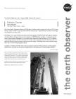
The Ocean Surface Topography Mission (OSTM)/Jason 2 satellite roared into space at 12:46 a.m. PDT on June 20 atop a Delta II rocket—see picture below. Fifty-five minutes later, it separated from the rocket’s second stage and unfurled its twin solar arrays.
OSTM/Jason 2 is a joint NASA/Centre National d’Etudes Spatiales (CNES) [French Space Agency] collaboration that builds on the legacy of two previous missions—TOPEX/Poseidon and Jason 1—and continues the record of ocean surface topography (i.e., sea surface height) observations that dates back to 1992. In addition to monitoring changes in sea level, measurements of ocean surface topography provide information about the speed and direction of ocean currents as well as ocean heat storage. Combining ocean current and heat storage data is key to understanding the global climate.
In addition to NASA and CNES, other mission participants include...
Read more...

