- Home
- Missions
- Data
- Communications
- People
- The Earth Observer Newsletter
Recent Imagery
You will be directed to the NASA Visible Earth webpage when you select Images by Mission below, or click on the images at right that are randomly generated to represent four out of all possible topics.
Celebrating Twenty Years of AERONET Research
Celebrating Twenty Years of AERONET Research
Submitted by Heather Hanson on Wed, 2013-05-22 09:05
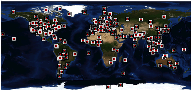
Congratulations to members of the AErosol RObotic NETwork (AERONET) program who celebrated 20 years of continuous automatic measurements on May 15, 2013. The program is a federation of ground-based remote sensing aerosol networks established by NASA and the PHOTONS network that provides a long-term, continuous, and readily accessible public domain database of aerosol optical, microphysical, and radiative properties for aerosol research and characterization, validation of satellite retrievals, and synergism with other databases.
Through collaboration with colleagues, universities, and agencies across the globe, AERONET has greatly expanded and now supports over 500 instruments and approximately 400 sites in more than 80 countries and territories. AERONET pioneered NASA’s open data policy resulting in over 3000 citations in peer reviewed journal articles on all phases of remote sensing of aerosol research. AERONET’s dedicated staff continues research while providing the highest quality science data and is planning the release of further improved (Version 3) data products in 2013 that will benefit the land, oceanic, and atmospheric research communities. For more information and data access, visit: aeronet.gsfc.nasa.gov.

May 15, 1993
May 15, 2013