- Home
- Missions
- Data
- Communications
- People
- The Earth Observer Newsletter

Recent Imagery
You will be directed to the NASA Visible Earth webpage when you select Images by Mission below, or click on the images at right that are randomly generated to represent four out of all possible topics.

You are here
Postcards
NASA's Earth Observing System provides a variety of materials available for download. Feel free to choose a category below:
- Brochures
- Postcards
- Posters
- Science Writers’ Guide
- Mission Brochures
- Fact Sheets
- Calendars
- Booklets
- Lithographs
- Reference and Data Products Handbooks
- iBooks
- Activities
 |
NASA's Hyperwall: Revealing the Big Picture (2011) We invite you to explore science at NASA. From the universe, to your backyard, we’ve got something to show you! Wondering what The Big Picture on the front of these two cards is all about? Find out on the other side. For starters, we’ve chosen a few examples of stories you may have seen on NASA’s Hyperwall. But that’s not all, you’ll also find links that allow you to discover extraordinary examples of our changing planet, and watch fascinating visualizations from NASA’s Scientific Visualization Studio. This publication appears in: |
 |
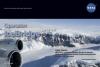
Operation IceBridge Aerial Views of Polar Ice (2010) Send a "note from the field" with a postcard featuring an image from Operation IceBridge, NASA’s six-year airborne mission to monitor Earth’s polar ice sheets, glaciers, and sea ice. Display the front of the card to showcase a spectacular image from the mission. Turn the card over to read factoids and learn about the ice at Earth’s polar regions -- a major factor in the global climate system. Data collected during IceBridge is helping scientists maintain polar observations between NASA’s Ice, Cloud, and land Elevation Satellite (ICESat), which stopped collecting science data in 2009, and ICESat-2, planned for late 2015. The mission is also yielding an unprecedented 3D view of targeted regions of interest, such as the dramatically retreating Jakobshavn Glacier in Greenland. This publication appears in: |
 |
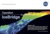
Operation IceBridge Aerial Views of Polar Ice (2010) Send a "note from the field" with a postcard featuring an image from Operation IceBridge, NASA’s six-year airborne mission to monitor Earth’s polar ice sheets, glaciers, and sea ice. Display the front of the card to showcase a spectacular image from the mission. Turn the card over to read factoids and learn about the ice at Earth’s polar regions -- a major factor in the global climate system. Data collected during IceBridge is helping scientists maintain polar observations between NASA’s Ice, Cloud, and land Elevation Satellite (ICESat), which stopped collecting science data in 2009, and ICESat-2, planned for late 2015. The mission is also yielding an unprecedented 3D view of targeted regions of interest, such as the dramatically retreating Jakobshavn Glacier in Greenland. This publication appears in: |
 |
Operation IceBridge Aerial Views of Polar Ice (2010) Send a "note from the field" with a postcard featuring an image from Operation IceBridge, NASA’s six-year airborne mission to monitor Earth’s polar ice sheets, glaciers, and sea ice. Display the front of the card to showcase a spectacular image from the mission. Turn the card over to read factoids and learn about the ice at Earth’s polar regions -- a major factor in the global climate system. Data collected during IceBridge is helping scientists maintain polar observations between NASA’s Ice, Cloud, and land Elevation Satellite (ICESat), which stopped collecting science data in 2009, and ICESat-2, planned for late 2015. The mission is also yielding an unprecedented 3D view of targeted regions of interest, such as the dramatically retreating Jakobshavn Glacier in Greenland. This publication appears in: |
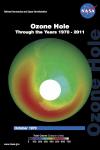 |
Ozone Hole: Through the Years 1970-2011 (2012) This card shows the monthly-averaged total ozone over Antarctica in October of 1970, 1979, 1984, 1989, 2000, and 2011. Also, find out what could have happened to the Earth’s ozone layer by 2063. This publication appears in: |
Pages
- « first
- ‹ previous
- 1
- 2
- 3
- 4