- Home
- Missions
- Data
- Communications
- People
- The Earth Observer Newsletter
Recent Imagery
You will be directed to the NASA Visible Earth webpage when you select Images by Mission below, or click on the images at right that are randomly generated to represent four out of all possible topics.

You are here
Lithographs
NASA's Earth Observing System provides a variety of materials available for download. Feel free to choose a category below:
- Brochures
- Postcards
- Posters
- Science Writers’ Guide
- Mission Brochures
- Fact Sheets
- Calendars
- Booklets
- Lithographs
- Reference and Data Products Handbooks
- iBooks
- Activities
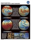 |
Energy Management (2003) Our nation is critically dependent on stable and reliable sources of energy. Traditionally, much of this demand has been met by burning fossil fuels such as oil, coal, and natural gas, but in recent years, considerable evidence has been amassed that these fuels can impact our environment, and alternative sources of fuel have been explored. Nuclear energy has been put forth as a cleaner alternative and used successfully in a few places but this source is not without its own set of environmental concerns. Other alternatives to fossil fuels are now emerging, including renewable energy technologies (RETs) like solar energy and wind power, and biomass fuels such as corn-based ethanol and other species under development. These alternative fuel sources can help reduce mankind’s dependence on fossil fuels and, at the same time, may help to improve our quality of air. This publication appears in: |
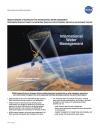 |
International Water Management (2010) NASA’s Applied Sciences Program provides remote sensing and technology information for international water management. Information from NASA is used for society’s benefit, in areas such as water resource planning and management, famine early warning and drought monitoring, food security predictions, disaster management, and water quality. International water management projects are of particular importance in addressing the issues that developing nations and data limited regions face. This publication appears in: |
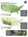 |
Invasive Species (2006) Invasive species may be defined as a non-native plant, animal, or microbe whose introduction causes, or is likely to cause, harm to the economy, the environment, or human health. Increasing globalization—the rapid transportation of people and goods throughout the Earth—provides the opportunity and the mechanism for such species to enter the United States and thrive in new habitats. Each year, the U.S. incurs direct losses of approximately $120 billion dollars due to these invasive species—an annual cost greater than most natural disasters combined. This publication appears in: |
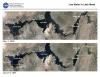 |
Low Water in Lake Mead (2003) About 96% of the water in Lake Mead is from melted snow that falls in Colorado, Utah, New Mexico, and Wyoming. The past two years have brought severe drought to the western states, and Colorado River runoff has been far below normal during this period. The effect is a drop in lake levels that is visible from NASA satellites. One of NASA’s Earth Science Enterprise research focus areas is the global water and energy cycle governing the precipitation, evaporation, storage and runoff of water. The Earth Science Enterprise Applications Program facilitates the practical use of this knowledge by national and regional decision makers for better management of fresh water resources. This publication appears in: |
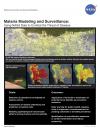 |
Malaria Modeling and Surveillance (2010) The goal of the Malaria Modeling and Surveillance project is to enhance the decision support capabilities of the Air Force Special Operation Command to combat the threat of malaria. The transmission of malaria is influenced by environmental and climatic factors; data from remote sensing instruments are key components to malaria monitoring and control models. Remotely sensed observations, including temperature, precipitation, vegetation density, and humidity, are essential components to this project, as well as Earth science models for climate prediction. This lithograph discusses NASA’s contributions to the Malaria Modeling and Surveillance project. This publication appears in: |
 |
MISR (2001) MISR measures the variation of surface and cloud properties, and particles in the atmosphere, with cameras pointed in nine simultaneous different viewing directions. MISR monitors monthly, seasonal, and long-term interactions between sunlight and these components of Earth’s environment. This is related to the following mission(s): This publication appears in: |
 |
MODIS (2001) The Moderate Resolution Imaging Spectroradiometer (MODIS) measures the atmosphere, land and ocean processes, (including surface temperature of both the land and ocean), ocean color, global vegetation, cloud characteristics, temperature and moisture profiles, and snow cover. MODIS views the entire surface (land, oceans, clouds, aerosols, etc.) of the Earth every one to two days at a "moderate resolution" of one quarter to one kilometer. This is related to the following mission(s): This publication appears in: |
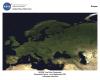 |
MODIS-Europe (2003) This spectacular Moderate Resolution Imaging Spectroradiometer (MODIS) image of Europe is based on the most detailed truecolor image of the entire Earth to date. Using a collection of satellite-based observations, scientists and visualizers stitched together months of observations of the land surface, oceans, sea ice, and clouds into a seamless, true-color mosaic of every square kilometer of our planet. This publication appears in: |
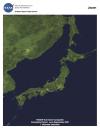 |
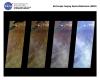
MODIS-Japan (2003) This spectacular Moderate Resolution Imaging Spectroradiometer (MODIS) image of Japan, eastern North and South Korea, northeast China, and southeast Russia is based on the most detailed true-color image of the entire Earth to date. Using a collection of satellite-based observations, scientists and visualizers stitched together months of observations of the land surface, oceans, sea ice, and clouds into a seamless, true-color mosaic of every square kilometer of our planet. This publication appears in: |
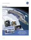 |
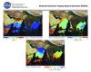
Operation IceBridge (2010) What’s Operation IceBridge all about? This one-pager sums it up, highlighting images and facts that characterize NASA’s six-year airborne mission to monitor Earth’s polar ice sheets, glaciers and sea ice. Display the front of the lithograph to showcase flight lines from the 2010 campaign over Arctic sea ice and Greenland’s land ice. Turn the lithograph over to read about the mission’s science goals, aircraft and instruments. This publication appears in: |