
You are here
Science Communication Material
NASA's Earth Observing System provides a variety of materials available for download. Feel free to choose a category below:
- Brochures
- Postcards
- Posters
- Science Writers’ Guide
- Mission Brochures
- Fact Sheets
- Calendars
- Booklets
- Lithographs
- Reference and Data Products Handbooks
- iBooks
- Activities
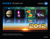 |
2012 NASA Science Mission Directorate Calendar |
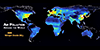 |
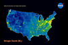
Air Pollution Around the World, 2005-2010 An at-a-glance tour of the world's nitrogen dioxide (NO2) pollution during the years 2005 and 2010. Discover how population correlates with this important pollutant and where its concentration has changed over time. This publication appears in: |
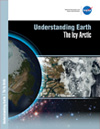 |
Understanding Earth: The Icy Arctic Over the last decade, satellite data—often combined with data from other sources—have revealed that the Arctic is changing at rates faster than anywhere else on Earth. These changes are interrelated and have both long- and short-term effects on Earth’s land surfaces, oceans, and atmosphere, ultimately impacting the Earth’s climate system. To better understand the Arctic environment, scientists at NASA are working in collaboration with various experts from other federal agencies, universities, private companies, and not-for-profit organizations. This booklet—the third in the Understanding Earth series—explains how NASA keeps a close eye on the Arctic and how the changes taking place there are affecting you. This publication appears in: |
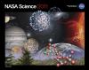 |
2011 NASA Science Mission Directorate |
 |
Assessing Air Quality from Space Learn about the direct connection between population density in the United States and air pollution in this striking comparison between 3 maps: the 2010 census, U.S. city lights at night, and nitrogen dioxide concentration. This publication appears in: |
 |
Glory Glory will improve measurements of two critical parts of the climate system: small airborne particles called aerosols and a measure of the sun’s output called total solar irradiance (TSI). This guide is a resource for science writers and journalists, providing contact information for experts working on the mission; information on the spacecraft, its instruments, and the science behind the Glory mission; feature stories about aerosols, the sun’s energy, and how these elements affect our climate. *Glory was lost in a vehicle launch failure. This is related to the following mission(s): This publication appears in: |
 |
Suomi NPP Understanding, monitoring, and predicting the course of long-term climate change and short-term weather fluctuations remains a task of profound importance. Economic competitiveness, human health and welfare, and global security all depend in part on our ability to understand and adapt to environmental changes. This is related to the following mission(s): This publication appears in: |
 |
Understanding Earth: Biomass Burning When biomass is burned, copious amounts of gases and particulate matter are released, billowing smoke plumes can fill the sky, and entire ecosystems can change in seconds. Fortunately, NASA’s Earth-observing satellites are able to monitor these changes, critical for understanding the effects biomass burning has on Earth’s atmosphere and climate system. This booklet—second in the Understanding Earth series—explains the causes and effects of biomass burning. You’ll learn about the wildfires that burned across western Russia in 2010, the 2011 Wallow Fire in Arizona that burned for nearly 984 hours, NASA’s ARCTAS mission, and more. “Understanding Earth: Biomass Burning” offers a variety of images and shows how NASA satellites provide a unique vantage point to observe and study these events. This publication appears in: |
 |
2010 NASA Science Mission Directorate |
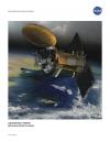 |
Aquarius SAC-D The Aquarius/SAC-D mission maps salinity at the ocean surface to improve our understanding of Earth’s water cycle and ocean circulation. Changes in Earth’s water cycle lead to increases and decreases in ocean surface salinity, and the variations in salinity influence ocean circulation and climate. Accurate global maps of salinity made with data from Aquarius show scientists long-term changes in this important parameter. This is related to the following mission(s): This publication appears in: |