- Home
- Missions
- Data
- Communications
- People
- The Earth Observer Newsletter
Recent Imagery
You will be directed to the NASA Visible Earth webpage when you select Images by Mission below, or click on the images at right that are randomly generated to represent four out of all possible topics.

You are here
Science Communication Material
NASA's Earth Observing System provides a variety of materials available for download. Feel free to choose a category below:
- Brochures
- Postcards
- Posters
- Science Writers’ Guide
- Mission Brochures
- Fact Sheets
- Calendars
- Booklets
- Lithographs
- Reference and Data Products Handbooks
- iBooks
- Activities
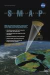 |
SMAP An overview of the Soil Moisture Active Passive (SMAP) satellite mission in poster format. This is related to the following mission(s): This publication appears in: |
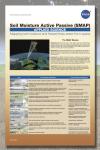 |
SMAP Applied Science A complete description of the Soil Moisture Active Passive mission; the mission overview at-a-glance and the science driving the mission. This is related to the following mission(s): This publication appears in: |
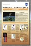 |
SMAP Products This poster shows sample products from the Soil Moisture Active Passive satellite mission. This is related to the following mission(s): This publication appears in: |
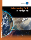 |
Understanding Earth: The Journey of Dust In April 2001, the “Perfect Dust Storm” struck when wind whipped dust from deserts in Mongolia and China over Eastern Asia and the Pacific Ocean. Sensors aboard NASA Earth observing satellites tracked the movement and density of the aerosols as the cloud traveled eastward for more than two weeks. The booklet, “Understanding Earth: The Journey of Dust,” explains the causes of the 2001 storm, the effects of dust storms on society and climate, and possible ways to minimize their frequency. With satellite imagery, “The Journey of Dust” shows how NASA satellites provide a unique vantage point to observe and study these large-scale events. This publication appears in: |
 |
2009 NASA Science Mission Directorate |
 |
NASA Earth News Summary Spring NASA Earth News is a 2-page summary of some of the latest features about Earth science at NASA. 'NASA Earth News' is published quarterly and can be downloaded here in a printable format. This publication appears in: |
 |
NASA Earth News Summary Summer NASA Earth News is a 2-page summary of some of the latest features about Earth science at NASA. ‘NASA Earth News’ is published quarterly and can be downloaded here in a printable format. This publication appears in: |
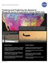 |
Tracking and Predicting the Spread of Mosquito-borne Encephalitis Using NASA Data Mosquitoes obtain encephalitis virus from infected birds and pass it on to humans. This lithograph explains how NASA is working to provide decision makers on the front lines of public health with innovative technologies and satellite data that are tailored into useful tools for combating this deadly disease. This publication appears in: |
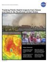 |
Tracking Public Health Impacts from Ozone and Dust in the Southwest U.S. Many airborne contaminants exacerbate existing health problems, increase health care costs, and reduce a person’s ability to work. The Environmental Public Health Application Systems (ENPHASYS) project bridges individual and community health by forecasting atmospheric ozone, dust, and other aerosols that trigger asthmatic responses or myocardial infarction (MI). This lithograph discusses how NASA satellite data is assimilated into the Community Multiscale Air Quality Modeling System (CMAQ) and Dust REgional Atmospheric Model (DREAM) models to produce ozone, aerosol, and dust forecasts that can be used to generate relevant health-related information. This publication appears in: |
 |
2008 NASA Science Mission Directorate Calendar |