- Home
- Missions
- Data
- Communications
- People
- The Earth Observer Newsletter
Recent Imagery
You will be directed to the NASA Visible Earth webpage when you select Images by Mission below, or click on the images at right that are randomly generated to represent four out of all possible topics.

You are here
Science Communication Material
NASA's Earth Observing System provides a variety of materials available for download. Feel free to choose a category below:
- Brochures
- Postcards
- Posters
- Science Writers’ Guide
- Mission Brochures
- Fact Sheets
- Calendars
- Booklets
- Lithographs
- Reference and Data Products Handbooks
- iBooks
- Activities
 |
Terra The launch of NASA’s Terra spacecraft in 1999, marked a new era of comprehensive monitoring of the Earth’s atmosphere, oceans, and continents from a single space-based platform. Data from the five Terra instruments are creating continuous, long-term records of the state of the land, oceans, and atmosphere. Together with data from other satellite systems launched by NASA and other countries, Terra inaugurated a new 15-year data record. This is related to the following mission(s): This publication appears in: |
 |
Advanced Spaceborne Thermal Emission and Reflection Radiometer (ASTER) The only instrument flying on the EOS Terra (formerly AM-1) platform that acquires high-resolution images is ASTER. The primary goal of the ASTER mission is to obtain high-resolution image data in 14 channels over targeted areas of the Earth’s surface, as well as black-and-white stereo images. With a revisit time between 4 and 16 days, ASTER provides the capability for repeat coverage of changing areas on the Earth’s surface. This is related to the following mission(s): This publication appears in: |
 |
Multi-angle Imaging Spectroradiometer (MISR) MISR is flying on the National Aeronautics and Space Administration’s (NASA’s) first Earth Observing System (EOS) satellite—EOS Terra (formerly AM-1)—together with four other instruments designed to study Earth from space. The Jet Propulsion Laboratory (JPL) of the California Institute of Technology built the MISR instrument for NASA. JPL, in collaboration with the MISR science team, built the software to convert raw MISR data into information that Earth science researchers can use. This is related to the following mission(s): This publication appears in: |
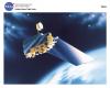 |
Terra NASA’s commitment to studying the Earth as a global system continued with the launch of the Terra spacecraft in December 1999 representing a key contribution by NASA to the U.S. Global Change Research Program. Terra was the first of several EOS spacecraft that are observing the Earth’s continents, oceans and atmosphere. It has five state-of-the-art instruments achieving measurement capability and accuracy never known before. This is related to the following mission(s): This publication appears in: |
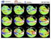 |
1997-98 El Nino (1998) This image shows the progression of the 1997-98 El Niño as derived rom the TOPEX/Poseidon satellite. This publication appears in: |
 |
AERONET (2012) This resource gives a brief overview of the AErosol RObotic NETwork (AERONET) program, which provides a long-term, accessible database of aerosol properties. Long-term commitment to AERONET sites worldwide provides assessment of the regional climatological impact of aerosols (e.g., aerosol amount, size, and heating or cooling effects). Learn more about this international program and how measurements from AERONET help improve our understanding of Earth’s climate. This publication appears in: |
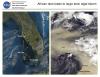 |
African Dust Leads to Large Toxic Algal Bloom (2001) Each year, several hundred million tons of African dust are transported westward over the Atlantic to the Caribbean, Gulf of Mexico, Central America, and South America. Thunderstorms and accompanying warm air can lift dust as high as 4575 meters (15,000 feet) above the African deserts, and then out across the Atlantic. This publication appears in: |
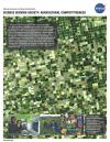 |
Agricultural Competitiveness (2003) One of our nations most vital needs is a stable and dependable food supply for an ever-increasing population. The Midwest United States is known as America’s Breadbasket because it is home to the vast majority of America’s productive farmland and is a vital cog in the American economy. Any disruption to the productivity of these lands can have devastating economic consequences. For example, in the summer of 1988, the Midwest United States experienced its worst dry spell since the 1930s causing an estimated $40 billion in crop damages. In contrast, summer 1993 was exceptionally wet, with flooding on the Missouri and Mississippi rivers that wreaked havoc on agricultural lands and caused extensive crop damage. This publication appears in: |
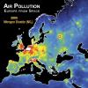 |
Air Pollution: Europe from Space, 2005-2010 (2012) A close-up look at air quality over Europe, 2005-2010, as detected from satellite. See how population and industrialization affects nitrogen dioxide (NO2) levels and how concentrations of this pollutant have changed over time. This publication appears in: |
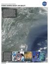 |
Air Quality (2003) The Clean Air Act, created in 1972 and last amended in 1990, responds to the basic societal need for clean, breathable air and recognizes the need to protect this vital natural resource. Congress directed the Environmental Protection Agency (EPA) to set National Ambient Air Quality Standards (NAAQS) for pollutants considered harmful to public health and the environment. Although these regulations have significantly improved the quality of our nation’s air over the past 30 years, people in some areas are still exposed to air pollution levels that exceed the NAAQS. Numerous studies have shown significant effects of air pollution on human health, agriculture, ecosystems, and physical infrastructure. This publication appears in: |