- Home
- Missions
- Data
- Communications
- People
- The Earth Observer Newsletter


Recent Imagery
You will be directed to the NASA Visible Earth webpage when you select Images by Mission below, or click on the images at right that are randomly generated to represent four out of all possible topics.

You are here
Science Communication Material
NASA's Earth Observing System provides a variety of materials available for download. Feel free to choose a category below:
- Brochures
- Postcards
- Posters
- Science Writers’ Guide
- Mission Brochures
- Fact Sheets
- Calendars
- Booklets
- Lithographs
- Reference and Data Products Handbooks
- iBooks
- Activities
 |
SORCE SORCE, launched in March 2003, aims to enable solar-terrestrial studies by providing precise daily measurements of the Total Solar Irradiance and the Spectral Solar Irradiance at wavelengths extending from the ultraviolet to the near infrared. This is related to the following mission(s): This publication appears in: |
 |
The Gravity Recovery And Climate Experiment (GRACE) To learn more about the mysteries of gravity, twin satellites named GRACE—short for the Gravity Recovery And Climate Experiment—were launched to make detailed measurements of Earth’s gravity field. This experiment could lead to discoveries about gravity and Earth’s natural systems, which could have far-reaching benefits to society and the world’s population. This is related to the following mission(s): This publication appears in: |
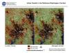 |
Urban Growth These images show the extent of land developed as urban, commercial and residential areas between 1986 and 2000, and projected development to 2030 in the Baltimore-Washington D.C. Metropolitan area. Past and current urban extent were derived using Landsat Thematic Mapper (TM) and Enhanced Thematic Mapper Plus (ETM+) satellite images. This publication appears in: |
 |
AIRS/AMSU/HSB The Atmospheric Infrared Sounder (AIRS), together with the Advanced Microwave Sounding Unit (AMSU) and the Humidity Sounder for Brazil (HSB) (Note: The HSB instrument failed after reaching orbit.) on the Aqua mission, represents the most advanced sounding system ever deployed in space. The system is capable of measuring the atmospheric temperature in the troposphere with radiosonde accuracies of 1 K over 1 km-thick layers under both clear and cloudy conditions, while the accuracy of the derived moisture profiles exceed that obtained by radiosondes. This is related to the following mission(s): This publication appears in: |
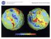 |
GRACE This lithograph displays the most accurate map to date of Earth’s long wavelength gravity field and is the first version to be released by NASA’s Gravity Recovery and Climate Experiment (GRACE) mission. We call these maps gravity anomaly maps because they show us how much Earth’s actual gravity field departs from "normal," as defined by a simplified mathematical gravity model that assumes the Earth is perfectly smooth and featureless. The maps reveal that the Earth is a restless, dynamic planet, both at its surface and deep within its interior. This is related to the following mission(s): This publication appears in: |
 |
MOPITT MOPITT is an infrared gas correlation radiometer that is making the first long-term global observations of carbon monoxide and methane as Terra circles the Earth from pole to pole, 14.4 times every day. From these measurements the sources, motions and sinks of CO can be determined. This publication appears in: |
 |
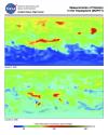
Advanced Microwave Scanning Radiometer for EOS (AMSR-E) How clouds, water vapor, precipitation, sea ice, soil moisture, and snow cover respond to increasing atmospheric levels of greenhouse gases is still unclear, and they all have the potential to either enhance or suppress global warming. The same can be said for their influence on natural climate fluctuations. The data that AMSR-E provides is being utilized by climate researchers to develop a better understanding of climate change. This is related to the following mission(s): This publication appears in: |
 |
EOS Data Products Handbook Volume 2 (2000) The EOS Data Products Handbook provides brief descriptions of the data products that are being produced from a range of missions of the Earth Observing System (EOS) and associated projects. Volume 1, originally published in 1997, covers the Tropical Rainfall Measuring Mission (TRMM), the Terra mission, and the Data Assimilation System, while Volume 2 covers the Active Cavity Radiometer Irradiance Monitor Satellite (ACRIMSAT), Aqua, Jason-1, Landsat 7, Meteor 3M/Stratospheric Aerosol and Gas Experiment III (SAGE III), the Quick Scatterometer (QuikScat), the Quick Total Ozone Mapping Spectrometer (QuikTOMS), and the Vegetation Canopy Lidar (VCL) missions. Volume 2 follows closely the format of Volume 1, providing a list of products and an introduction and overview descriptions of the instruments and data processing, all introductory to the core of the book which presents the individual data product descriptions, organized into 11 topical chapters. The product descriptions are followed by five appendices, which provide contact information for the EOS data centers that are archiving and distributing the data sets, contact information for the science points of contact for the data products, references, acronyms and abbreviations, and a data products index. This publication appears in: |
 |
Using Satellites to Track Rift Valley Fever Rift Valley Fever (RVF), at least in the African country of Kenya, has been well known for over 60 years. As early as 1913, a disease fitting the description of RVF was blamed for the loss of sheep in the Rift Valley in kenya. However, it was not until scientists studied an outbreak of the disease in 1931 that a virus was isolated and shown to cause the disease. By using satellites to closely monitor the vegetation in the region affected by increased rainfall, scientists can identify likely habitats for the mosquitoes that carry the RVF virus, and provide advance warning of large-scale outbreaks of the disease. This publication appears in: |
 |
1999 Earth Science Reference Handbook The 1999 EOS Reference Handbook provides a historical guide to the satellite missions and other elements of NASA's Earth science program, known then as the Earth Science Enterprise. This publication appears in: |